GPS Tracker All Informations
Free Version
Publisher Description
GPS Tracker All Informations - ►Tool based on GPS and the waypoints: calculation,geometry,statistics,mapping,++
Just for your entertainment ... or your business needs.
[ ► No ads, Free Software ◄ ]
Position GPS = Waypoint = WP
GPS tool for finding GPS positions and giving cartographic, geometric and statistical information.
There are many tools available, combining WPs to create geometric shapes, routes, lists or gather information for more complex processing.
Its objective is to provide all the information and tools possible associating the user (you), GPS positions, a calculator (your smartphone).
The information and results are displayed on the map (google map).
Sport routes can be saved automatically and displayed, processed, reused by integrated GPS tools.
WPs can be recorded in different ways:
- tactile input on map
- manually enter coordinates
- via periodic automatic recording
- via buttons on the interface
The interface is intuitive and based on a simple color code.
Touch capabilities are used, click on the maps to get information specific to the selected tool, select WP, ...
4 waypoints are accessed via a color code -Green, Blue, Red, Yellow-. This is to facilitate simple treatments (quick search, triangle, quadrilateral, circles ...).
The 4 color waypoints are interchangeable with those in the global list (via the manager).
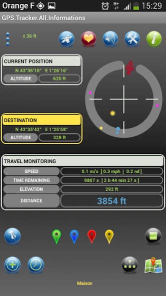
► Classic tracker GPS tool: find a GPS position like that of the car, at Grandma's, a corner with mushrooms ...
» Information given: the time remaining before contact, the distance remaining, the speed, the difference in altitude, ...
» Sound tracker function: the closer you get to a position, the smaller the difference between 2 beeps
» Compass with position of WP searched
Distance: "xxx m"
The distance separating us from the selected waypoint (for which the search is in progress)
This distance appears:
• Blue if one moves away (cold !)
• Red if you get closer (It heats up!)
• Green if you are close (= GPS accuracy)
[List of GPS tools]
------------------------
All available GPS tools use one or more of the following: current position, WPs of colors, WPs typed on the map, WPs of a list.
WPs describe geometric shapes, sets (paths), or are taken separately.
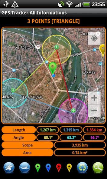
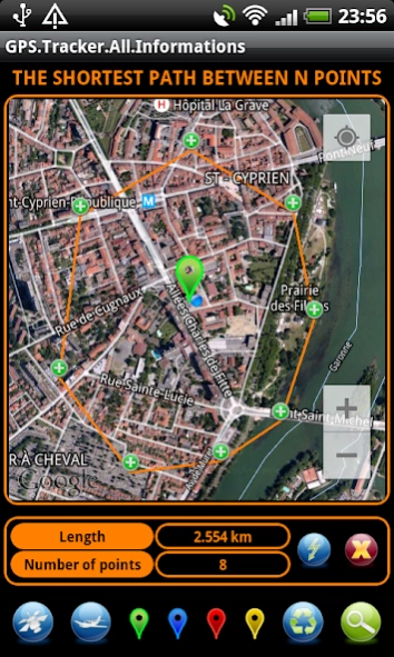
The treatments of these GPS tools provide information: distances, areas, lengths, perimeters, angles, paths, remarkable points, intersection points, projected points, heights, diagonals, medians, bisectors, incircle, circumcircle, ...
The results of the treatments are displayed on the map and on the screen.
► Information
• On the current position and WP
• Distances between WPs
• Statistics
• Proportional distance radar
► Maps
• Circles of equidistances (fixed, manual, tactile)
• Isochronous circles (fixed, manual)
• Circles of equidistance vs isochronous (fixed, manual)
• WPs display
• Nearby WPs
• Distant WPs
► Touch-mapping tools
• Distance between the current position and a WP
• Distance between 2 WP
• Cumulative distances between WP
• Polygons
• Angles
• Circles
• Triangle
• Quadrilateral
• Shortest path (between several WPs)
• Longest route
• Squares
• Segment intervals
► Specialized modules
• Distance from the horizon
• Mutual visibility between 2 objects
• Thunderstorm (analysis from thunder and lightning, determination of lightning position)
• Propagation of the sound wave
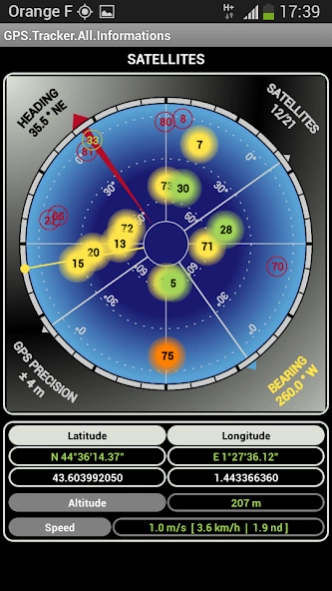
• Information about GPS satellites
► Geometry between WP colors
• Discs with the current position
• Discs between WP
• Triangle
• Quadrilateral
► Geometric Calculations
• Mid of segments
• Intersection of straight lines
• Distance from the WP to the right
• Tangent to the circle through a WP
• Intersection of circles
• Intersection of a circle and a line
► Transformations
• Rotation
• Homothetics
• Translation
• Central Symmetry
• Axial symmetry
• Trigonometry
► Operations on a set of WP
• View and route information
• Sorts, Statistics
About GPS Tracker All Informations
GPS Tracker All Informations is a free app for Android published in the System Maintenance list of apps, part of System Utilities.
The company that develops GPS Tracker All Informations is MARTIN Lucas. The latest version released by its developer is 1.0.
To install GPS Tracker All Informations on your Android device, just click the green Continue To App button above to start the installation process. The app is listed on our website since 2017-06-23 and was downloaded 3 times. We have already checked if the download link is safe, however for your own protection we recommend that you scan the downloaded app with your antivirus. Your antivirus may detect the GPS Tracker All Informations as malware as malware if the download link to com.gps.tracker is broken.
How to install GPS Tracker All Informations on your Android device:
- Click on the Continue To App button on our website. This will redirect you to Google Play.
- Once the GPS Tracker All Informations is shown in the Google Play listing of your Android device, you can start its download and installation. Tap on the Install button located below the search bar and to the right of the app icon.
- A pop-up window with the permissions required by GPS Tracker All Informations will be shown. Click on Accept to continue the process.
- GPS Tracker All Informations will be downloaded onto your device, displaying a progress. Once the download completes, the installation will start and you'll get a notification after the installation is finished.
